Why Does Tonlé Sap Change Size So Dramatically?
If you visit Tonlé Sap Lake in February, you might see a shallow, quiet body of water surrounded by dry land. Floating villages sit low on the waterline. Fishing boats move through narrow channels. The lake feels small and calm.
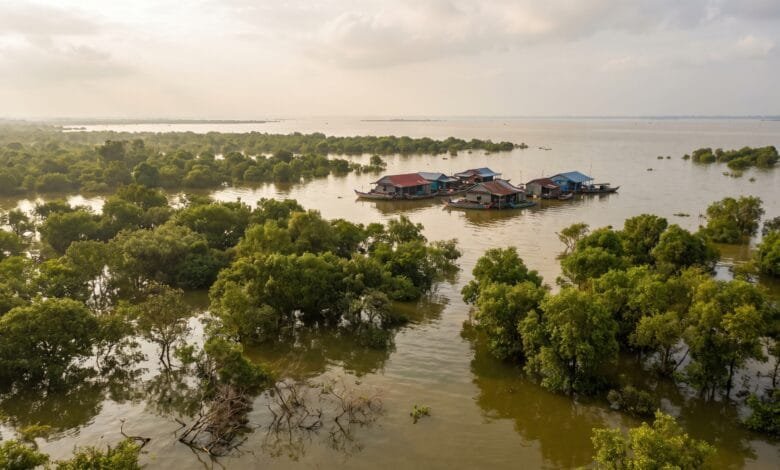
Come back in September, and you would barely recognize the place. The water has risen several meters. Entire forests are underwater. Floating villages have moved to new locations. The lake now stretches across the horizon.
This is not a slow, gradual change. It happens every single year.
Tonlé Sap is the largest freshwater lake in Southeast Asia, and its dramatic seasonal transformation is one of the most remarkable geographic phenomena in the world. Understanding why it happens helps travelers see Cambodia — and its relationship with water — in a completely different way.
The Short Answer: A River That Flows Backward
Most lakes change size a little between seasons. Tonlé Sap changes by 400% to 600%.
The reason is simple but unusual: the river that connects Tonlé Sap to the Mekong River reverses its flow direction every year.
During the dry season, the Tonlé Sap River flows normally — from the lake southeast toward the Mekong River, draining the lake like any ordinary river.
Then the monsoon rains arrive. The Mekong River swells dramatically. So much water pours down the Mekong that it cannot all escape to the sea. Some of it is pushed up the Tonlé Sap River — flowing backward, northward, into the lake.
The Tonlé Sap River is the lake’s only outlet. When water flows into the lake instead of out of it, there is nowhere for it to go. So the lake rises. And rises. And rises.
This happens every year, like clockwork. The Tonlé Sap River is the only river in the world that naturally reverses its flow on a regular seasonal basis.
How Big Does Tonlé Sap Get?
The difference between the dry season and the wet season is enormous.
Dry season (November to April):
- Surface area: approximately 2,500 to 3,000 square kilometers
- Average depth: about 1 meter
- The lake looks more like a shallow, reedy swamp than a great lake
Wet season (May to October):
- Surface area: approximately 10,000 to 15,000 square kilometers
- Average depth: 8 to 10 meters, with some areas reaching deeper
- The lake expands across surrounding forests and farmland
Some sources describe the lake expanding five or six times its dry-season size. The exact numbers vary year to year because rainfall, upstream dam operations, and other factors change how much water enters the system.
For a traveler, the practical difference is this: in April, you might see a modest lake surrounded by dry land. In September, you might see what looks like an inland sea.
What Is the Reversing River?
The Tonlé Sap River runs about 120 kilometers from the lake southeast to Phnom Penh, where it meets the Mekong River.
For most of the year, water flows from the lake down this river toward the Mekong. The lake drains slowly. Water levels drop. Fish move into remaining pools. Villages that float during the wet season begin to sit on exposed mud.
Then something remarkable happens.
Why the Mekong Pushes Water Uphill
The Mekong River is one of the largest rivers in the world. It begins in the Tibetan Plateau and flows through China, Myanmar, Laos, Thailand, Cambodia, and Vietnam before reaching the sea.
During the monsoon season (roughly May to October), heavy rain falls across the entire Mekong basin. The river carries an enormous volume of water southward.
When this flood of water reaches Phnom Penh, it meets the mouth of the Tonlé Sap River. The Mekong is so full and flowing so forcefully that water is pushed up the Tonlé Sap River — upstream, away from the sea, toward the lake.
This is the key geographic fact. The Mekong does not “choose” to push water into the lake. The simple physics of water seeking the lowest path means that when the Mekong is high enough, the Tonlé Sap River becomes an inlet rather than an outlet.
The reversal typically begins in early June, though it can start as much as a month earlier or later depending on when the monsoon arrives. The reverse flow usually lasts about four months, ending in late September or October when the Mekong’s water level drops.
Once the Mekong recedes, the Tonlé Sap River switches back to its normal direction. The lake drains. The cycle begins again.
The Flood Pulse: Why This Matters for Life in Cambodia
The seasonal expansion and contraction of Tonlé Sap is not just a curiosity for geographers. It is the engine that drives one of the most productive ecosystems on Earth.
Scientists call this cycle a “flood pulse” — a predictable, annual flood that connects a river to its floodplain and fuels extraordinary biological productivity.
The Flooded Forest
When the lake expands, it does not just fill empty space. It spreads into a vast surrounding forest — a unique ecosystem of trees and shrubs adapted to survive months of being completely underwater.
This flooded forest covers thousands of square kilometers around the lake’s perimeter during the wet season.
The flooded forest is where fish breed and feed. Nutrients from the forest — leaves, insects, organic matter — enter the water and become food for fish populations. The dense vegetation also provides shelter for young fish, protecting them from predators.
The flooded forest supports the largest breeding colonies of large waterbirds remaining in Southeast Asia. It is a critical habitat for endangered species including the hairy-nosed otter and various species of storks and ibises.
Fish, Food and Floating Villages
Tonlé Sap is one of the most productive freshwater fisheries in the world. It produces more freshwater fish than all of North America combined.
The lake supports approximately 280 to 300 fish species. Many of these fish depend on the flood pulse. They migrate from the Mekong River into the lake during the wet season, breed in the flooded forest, and then return to the Mekong as the water recedes.
For Cambodia, the lake is a lifeline. Its fish provide roughly 80% of the country’s animal protein consumption and represent about 10% of GDP. More than 4.6 million people depend directly or indirectly on the Tonlé Sap for food and income.
This is why the geography matters so much. The reversing river is not just an interesting natural phenomenon — it is the mechanism that feeds millions of people.
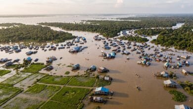
Floating villages on the lake are a direct human response to this geography. Houses are built on bamboo rafts or tall stilts so they can rise and fall with the water. During the wet season, entire communities — schools, shops, churches, basketball courts — float on the lake surface. During the dry season, the same villages sit on land or on exposed stilts ten meters high.
Approximately 80,000 people live in floating villages on the Tonlé Sap.
What Travelers Actually See
If you visit Tonlé Sap, what you see depends entirely on when you go.
Dry season (November to April):
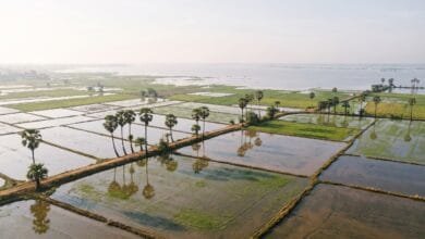
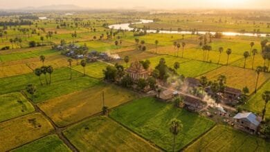
The lake is small and shallow. Water levels are low. You may be able to see the exposed roots of flooded forest trees. Floating villages have moved toward the center of the lake or sit on high stilts above dry ground. Birdwatching is excellent, especially at Prek Toal, because waterbirds concentrate around shrinking water bodies.
Wet season (May to October):
The lake is vast and deep. Flooded forests are fully submerged. Floating villages are genuinely floating, moving across the water surface. Boat trips take you through flooded forest canopies. The landscape looks completely different.
Many travelers visit Tonlé Sap as a side trip from Siem Reap. The most common destinations are the floating villages of Kampong Phluk and Kampong Khleang, both located in the northern part of the lake.
Boat trips operate year-round, but the experience varies dramatically. During the dry season, boats may navigate narrow channels. During the wet season, they glide across open water and through flooded forests.
The lake’s water levels typically peak between August and October and reach their lowest point between March and April. The “high water” period generally runs from mid-July to mid-February, while “low water” runs from mid-February to mid-July.
Is the Tonlé Sap Changing?
Yes, and the changes are significant.
Research published in 2025 found that the Tonlé Sap’s reverse flow — the amount of Mekong water that enters the lake each year — declined by 40% to 50% between 1998 and 2018.
The main cause is not climate change alone. It is sand mining and upstream sediment trapping on the Mekong River.
Here is what happens: sand mining deepens the Mekong riverbed. When the riverbed is deeper, water flows more easily downstream and does not rise as high. If the Mekong does not rise enough, it cannot push water up the Tonlé Sap River. So less water enters the lake.
Projections suggest that by 2038, the reverse flow could decline by up to 69% compared to 1998 levels. This would reduce the lake’s maximum flooded area by approximately 40%.
For Cambodia, this matters enormously. Less water in the lake means less flooded forest. Less flooded forest means fewer fish. Fewer fish means less food for millions of people.
Climate change adds another layer of pressure. Projections for 2050 indicate that Cambodia’s dry season could become hotter and drier, with maximum temperatures rising from 32°C to 35°C. Heavy rainstorms may become more intense, altering the timing of the flood pulse.
The Cambodian government has recognized these threats. In 2020, it placed a moratorium on new mainstream dams on the Mekong River within Cambodia. In 2021, Cambodia committed at the UN climate conference to not building any mainstream dams on the Mekong.
For travelers, this means that the Tonlé Sap they see today may not be exactly the Tonlé Sap that future generations see. The lake is resilient — it has survived for thousands of years — but it is under pressure.
Frequently Asked Questions
How big is Tonlé Sap in the dry season?
How big is Tonlé Sap in the wet season?
Why does the Tonlé Sap River flow backward?
When does the Tonlé Sap River reverse its flow?
The reverse flow typically begins in early June and ends in late September or October, though the exact timing varies from year to year depending on monsoon rainfall.
Is Tonlé Sap the largest lake in Southeast Asia?
What is a flood pulse?
A flood pulse is a predictable, annual flood that connects a river to its surrounding floodplain. The flood pulse is the key mechanism that drives the Tonlé Sap’s extraordinary biological productivity, including its fish populations and flooded forests.
Can you visit Tonlé Sap during the dry season?
Yes. Boat trips operate year-round. The dry season offers a different but equally interesting experience — lower water levels, exposed flooded forest, and excellent birdwatching, especially at the Prek Toal bird sanctuary.
Where is Tonlé Sap located?
Tonlé Sap is located in the central plains of Cambodia, in the northwestern part of the country. It is connected to the Mekong River by the Tonlé Sap River, which meets the Mekong at Phnom Penh. The lake lies south of the historic temples of Angkor and north of Cambodia’s capital city.
Conclusion
The Tonlé Sap changes size so dramatically because of one remarkable geographic fact: the river that drains it can also fill it.
Every year, the Mekong River rises with monsoon rains. Water is pushed backward up the Tonlé Sap River and into the lake. The lake expands across forests and farmland. Then the Mekong recedes, the river reverses again, and the lake drains.
This is not just an interesting geographic phenomenon. It is the foundation of Cambodia’s food system, the habitat for hundreds of fish species, and the reason floating villages exist. The flood pulse — the annual rhythm of expansion and contraction — is what makes Tonlé Sap one of the most productive freshwater ecosystems on Earth.
For travelers, understanding this cycle changes how you see the lake. If you visit during the dry season, you are seeing a dormant phase. If you visit during the wet season, you are seeing the lake at its full power. Neither version is “the real” Tonlé Sap. Both are part of a cycle that has repeated for thousands of years — and that now faces serious challenges from sand mining, dam construction, and climate change.
The next time you see a map of Cambodia with that blue shape in the center, remember: that shape is not fixed. It grows. It shrinks. It breathes with the Mekong. And it is one of the most extraordinary geographic systems in the world.