Cambodia’s Coastline: Geography of the Gulf of Thailand
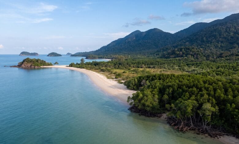
Cambodia is often pictured as a land of rice paddies, ancient temples, and a great lake at its center. But the country has another side — a coastline that stretches along the Gulf of Thailand for hundreds of kilometers.
This coast is more than a place to find a beach. It is a distinct geographic region with its own rainfall, its own ecosystems, and its own way of life. For travelers, understanding this coastline helps explain why the southern part of Cambodia feels so different from the rest of the country.
Quick Geography Information
| Information | Details |
|---|---|
| Country | Cambodia |
| Region | Southeast Asia (mainland) |
| Coastline | Approximately 435–443 km along the Gulf of Thailand |
| Coastal Provinces | Koh Kong, Preah Sihanouk, Kampot, Kep |
| Neighboring Water Body | Gulf of Thailand (historically called the Gulf of Siam) |
| Major Coastal Ecosystems | Mangroves, seagrass beds, coral reefs |
| Offshore Islands | Over 50 |
| Climate | Tropical monsoon; rainy season May–October, dry season November–April |
| Coastal Rainfall | 2,000–4,000 mm annually (among the wettest in Cambodia) |
Where Is Cambodia’s Coastline?
Cambodia sits in the heart of mainland Southeast Asia. It shares borders with Thailand to the west and northwest, Laos to the north, and Vietnam to the east and southeast.
The country’s southern and southwestern edge meets the Gulf of Thailand. This is Cambodia’s only direct access to the sea.
The Gulf of Thailand is a large, relatively shallow body of water. It is bordered by Cambodia, Thailand, Vietnam, and Malaysia. The gulf is part of the larger South China Sea system. For Cambodia, this coastline is not just a scenic feature. It is a gateway for trade, fishing, and tourism.
The Four Coastal Provinces
Cambodia’s coastline runs through four provinces and municipalities. From west to east, they are Koh Kong, Preah Sihanouk, Kampot, and Kep.
Together, these four areas cover about 10% of Cambodia’s land area and are home to roughly 7% of the country’s population. Each has a distinct geographic character.
Koh Kong — The Wild Western Coast
Koh Kong is Cambodia’s westernmost coastal province. It borders Thailand and has a long, largely undeveloped coastline.
Behind the coast, the land rises into the Cardamom Mountains. This mountain range is one of the largest remaining forested areas in Southeast Asia. The mountains create a dramatic backdrop to the coast and play a major role in the region’s weather.
Koh Kong has the largest mangrove forests in Cambodia. The province is also home to Botum Sakor National Park, a large protected area that stretches from the mountains to the sea.
Preah Sihanouk — The Port and Island Hub
Preah Sihanouk, often called Sihanoukville, is Cambodia’s most developed coastal province. It is home to Sihanoukville Autonomous Port, the country’s only deep-sea port.
The province has a coastline of about 176 km and includes around 32 islands. The most well-known islands are Koh Rong and Koh Rong Sanloem, both located in the Gulf of Thailand.
This is where Cambodia’s coastal geography meets its economic geography. The deep-water port is a key gateway for international shipping.
Kampot and Kep — The Eastern Coast
Kampot and Kep form the eastern part of Cambodia’s coastline. These two provinces are smaller and quieter than Sihanoukville.
Kep is a small municipality with just 16 km of coastline. Kampot, its larger neighbor, has a mix of coastal plains, rivers, and foothills from the Elephant Mountains.
The Kampot River flows through this region and meets the sea at Kampot town. The area is known for its seagrass meadows, which are among the most extensive in Cambodia.
What the Coastline Actually Looks Like
Cambodia’s coastline is not a straight line. It is heavily indented, with peninsulas, bays, estuaries, and river mouths.
This shape matters. The indentations create sheltered areas where mangroves can grow. They also form natural harbors, which is why Sihanoukville became the site of Cambodia’s main port.
The coast is backed by mountains for much of its length. The Cardamom Mountains and the Elephant Mountains rise close to the sea in the western and central parts of the coast. In some places, the transition from beach to mountain forest happens over just a few kilometers.
This creates a landscape that is quite different from Cambodia’s central plains. Instead of flat rice fields stretching to the horizon, the coast offers a tight, dramatic meeting of land and water.
Islands in the Gulf of Thailand
Cambodia has more than 50 islands in the Gulf of Thailand. They are scattered along the coast, from Koh Kong in the west to Kep in the east.
The largest island is Koh Kong, located off the coast of the province with the same name. It covers about 105 km².
Koh Rong is the second-largest and most well-known island. It lies about 25 km from Sihanoukville and has an area of roughly 78 km². About 43 km of its 61 km coastline is beach.
Other notable islands include Koh Rong Sanloem, Koh Sdach, and Koh Tonsay (Rabbit Island) near Kep.
Geographically, these islands are part of the same coastal system as the mainland. They share similar geology, climate, and ecosystems. Their beaches and coral reefs are shaped by the same currents and seasonal patterns that affect the mainland coast.
Why Coastal Cambodia Is Wetter Than the Rest of the Country
If you look at rainfall patterns in Cambodia, one thing stands out: the coast is much wetter than the interior.
Average annual rainfall in Cambodia’s central lowlands is around 1,400 mm. On the coast, it can reach 2,000 to 4,000 mm.
Why? The answer is geography.
During the rainy season, from May to October, winds blow from the southwest. These winds carry moisture from the Gulf of Thailand. When the moist air hits the Cardamom Mountains and Elephant Mountains, it is forced upward. As the air rises, it cools, and the moisture falls as rain.
This is called orographic rainfall — rain caused by mountains. The coast sits directly in the path of this moisture, so it receives the heaviest rain.
The result is a coastal zone that is greener, wetter, and more humid than inland Cambodia. It also means that travelers visiting the coast during the rainy season should expect frequent, sometimes heavy, afternoon downpours.
Mangroves, Seagrass, and Coral Reefs
The coastal zone supports three major ecosystems: mangroves, seagrass beds, and coral reefs.
Mangroves are trees that grow in saltwater along tropical coastlines. They have tangled roots that trap sediment and protect the shore from erosion and storms. Cambodia’s mangroves are concentrated in Koh Kong, with smaller areas in Kampot, Preah Sihanouk, and Kep.
Mangroves are important nurseries for fish. Many species of fish and shrimp spend their early lives among mangrove roots. This is why coastal communities that protect mangroves often see healthier fish populations.
However, Cambodia’s mangroves have declined sharply. More than 40% of mangrove forests were cleared between 1989 and 2017, mainly for charcoal production, shrimp farming, and salt farming.
Seagrass beds are underwater meadows of flowering plants. They grow in shallow coastal waters and provide food and shelter for fish, sea turtles, and other marine life. Cambodia has 11 species of seagrass — the highest diversity in mainland Southeast Asia.
The largest seagrass meadows are in the Kep–Kampot corridor and around islands in Preah Sihanouk.
Coral reefs surround many of Cambodia’s islands. They are fringing reefs — reefs that grow close to the shore. They support a wide variety of reef fish and invertebrates.
The health of Cambodia’s coral reefs varies. A 2023 assessment found that live coral cover near Koh Rong had fallen to about 32%, down from 48% in 2010. Sedimentation, pollution, and rising water temperatures are among the pressures.
How Geography Shapes Life on the Coast
Geography is not just about land and water. It shapes how people live.
Fishing and Farming
The coastal provinces are important for Cambodia’s fishing industry. Together, they contribute roughly one quarter of the national fish catch. Preah Sihanouk and Koh Kong produce the majority of marine landings.
Fishing on the coast is mostly small-scale. Many families use small boats and traditional methods. The health of mangroves, seagrass, and coral reefs directly affects their catch.
Farming also happens on the coast, but it looks different from inland Cambodia. Rice is still grown, but the coastal climate — with its longer rainy season — supports other crops as well.
The Kampot Pepper Connection
One of the clearest examples of geography shaping food is Kampot pepper.
This pepper is grown in specific districts of Kampot and Kep provinces. The area has a unique microclimate: the rainy season lasts longer than in other parts of Cambodia, and annual rainfall is higher than 2,000 mm.
The soil is also important. The porous soils around Phnom Voa mountain allow good drainage during the rainy season. This combination of climate and soil gives Kampot pepper its distinctive flavor.
In 2010, Kampot pepper was registered as a Geographical Indication in Cambodia. This means that only pepper grown in this specific geographic area can be sold under the Kampot name.
What Travelers Notice
If you travel to Cambodia’s coast, you will notice several things that are directly shaped by geography.
The rain. If you visit during the wet season, you will quickly understand why this is one of the wettest parts of Cambodia. Rain can be heavy and sudden.
The greenery. The coast is lush. Mangroves, coconut palms, and dense forest cover the land. This is a direct result of the high rainfall.
The mountains behind the coast. In many places, you can see mountains rising just behind the beach. The Cardamom and Elephant Mountains are never far from the sea.
The changing coastline. The coast is not uniform. In some places, you find long sandy beaches. In others, rocky headlands, muddy estuaries, or mangrove forests dominate.
The islands. From Sihanoukville, you can see islands on the horizon. They are a short boat ride away and offer a different perspective on the same coastal geography.
Frequently Asked Questions
Where is Cambodia’s coastline?
Cambodia’s coastline is in the country’s south and southwest, along the Gulf of Thailand. It runs through four provinces: Koh Kong, Preah Sihanouk, Kampot, and Kep.
How long is Cambodia’s coastline?
It is approximately 435–443 km long. Different sources give slightly different figures, but 435 km is the most commonly cited.
Which sea is Cambodia on?
Cambodia is on the Gulf of Thailand, which is part of the South China Sea system. It is a shallow gulf bordered by Cambodia, Thailand, Vietnam, and Malaysia.
Is Cambodia’s coast good for swimming?
Yes, many beaches along the coast are suitable for swimming, especially on the islands and in Sihanoukville. However, travelers should always check local conditions and be aware of seasonal weather.
Why is coastal Cambodia so wet?
The Cardamom and Elephant Mountains force moist air from the Gulf of Thailand upward. As the air rises, it cools and releases rain. This makes the coast one of the wettest parts of Cambodia.
How many islands does Cambodia have?
Cambodia has more than 50 islands in the Gulf of Thailand. The largest is Koh Kong, and the most well-known is Koh Rong.
What is the best time to visit Cambodia’s coast?
The dry season, from November to April, offers the most reliable weather for beach activities. The rainy season, from May to October, brings heavy but often short-lived downpours.
Conclusion
Cambodia’s coastline is a geographic region shaped by mountains, monsoons, and the sea. The Cardamom Mountains push rain onto the coast, making it one of the wettest places in the country. The indented shoreline creates mangrove forests, seagrass meadows, and coral reefs. The Gulf of Thailand provides Cambodia with its only maritime gateway.
For travelers, understanding this geography changes the experience. The coast is not just a place to relax. It is a place where the country’s physical character — its mountains, its water, and its climate — comes together in a distinct and memorable way.