The Cambodia You See Depends on Where You Go: A Geography Overview
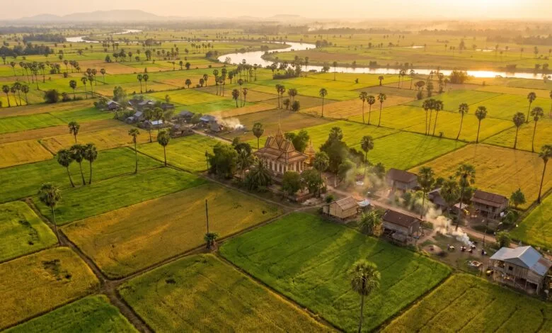
Many travelers arrive in Cambodia expecting one landscape: flat rice fields, scattered palm trees, and ancient temples rising from the plain. That picture is real — in some parts of the country. But travel a few hours in another direction, and Cambodia changes completely.
Head southwest from Phnom Penh and the land rises into dense rainforest mountains. Drive north toward the Thai border and you climb a steep escarpment. Follow the Mekong River east toward Vietnam and the landscape opens into wide floodplains. Cambodia is a country of distinct geographic regions, each shaped by water, elevation, and climate.
Understanding this geography helps you see Cambodia more clearly — not just as a destination, but as a country where land and water have shaped how people live for centuries.
Where Is Cambodia?
Cambodia sits in the southern part of the Indochina Peninsula in Southeast Asia. It is bordered by Thailand to the northwest and west, Laos to the northeast, Vietnam to the east and southeast, and the Gulf of Thailand to the southwest.
The country covers approximately 181,035 square kilometers — roughly the size of the US state of Missouri. Its total land boundaries stretch about 2,572 kilometers: 803 kilometers with Thailand, 1,228 kilometers with Vietnam, and 541 kilometers with Laos.
Cambodia’s coastline runs about 435 to 443 kilometers along the Gulf of Thailand. Four provinces share this coast: Koh Kong, Kampot, Kep, and Preah Sihanouk.
For travelers from the United States, it helps to picture Cambodia as slightly smaller than Missouri, tucked between three larger neighbors, with a short but important coastline on the Gulf of Thailand.
A Country Shaped by Water
If there is one geographic feature that defines Cambodia, it is water. Two connected water systems — the Mekong River and the Tonle Sap — dominate the country’s geography, agriculture, and daily life.
The Mekong River
The Mekong is one of the world’s great rivers. It begins on the Tibetan Plateau and flows through China, Myanmar, Thailand, Laos, Cambodia, and Vietnam before emptying into the South China Sea.
In Cambodia, the Mekong flows from north to south for about 480 kilometers. Its drainage basin covers about 86% of Cambodia’s land area. The river’s annual flooding deposits nutrient-rich sediment across the central plains, making the soil highly fertile for rice farming.
The Mekong is not just a geographic feature — it is a working river. It supports fisheries, provides water for irrigation, and serves as a transportation route for people and goods.
The Tonle Sap: Cambodia’s Great Lake
The Tonle Sap is the largest permanent freshwater lake in Southeast Asia. It sits in the center of Cambodia, northwest of Phnom Penh, and is connected to the Mekong by the Tonle Sap River.
What makes the Tonle Sap unusual is its seasonal rhythm. During the dry season, the lake shrinks to roughly 2,500–3,000 square kilometers. Then, as the Mekong swells with monsoon rains, the Tonle Sap River reverses its flow — pushing water backward into the lake instead of draining it.
The lake expands dramatically, reaching 10,000 to 16,000 square kilometers at its peak. The surrounding floodplain forests become breeding and feeding grounds for fish. The Tonle Sap is one of the most productive freshwater fisheries in the world.
For travelers, this means the Tonle Sap looks different depending on when you visit. In the dry season, you see a smaller lake with floating villages sitting low on the water. In the wet season, the lake becomes an inland sea, and the flooded forests fill with fish, birds, and boats.
Cambodia’s Three Main Geographic Regions
Cambodia’s landscape is often divided into three broad geographic regions: the central plains, the mountains and plateaus, and the coastal zone. Each has its own character, climate, and way of life.
The Central Plains: Cambodia’s Rice Bowl
The central plains cover roughly three-quarters of Cambodia’s land area. This is the low-lying heart of the country, built up over thousands of years by sediment deposited by the Mekong River and the Tonle Sap.
The plains are mostly flat, with isolated hills (called phnom in Khmer) rising here and there. The soil is fertile, and this is where most of Cambodia’s rice is grown. It is also where most Cambodians live — the population concentrates in the flood-prone areas along the Mekong and around the Tonle Sap.
Phnom Penh, the capital, sits at the confluence of the Mekong, Tonle Sap, and Bassac rivers in the south-central part of the plains. The city’s location was chosen for its access to water — a geographic advantage that has shaped Cambodia’s history for centuries.
Travelers crossing the central plains by bus or car will notice a landscape of rice paddies, sugar palm trees, small villages, and occasional temple hills. It is beautiful in its simplicity, but it is also a landscape shaped by the annual cycle of flood and dry season.
Mountains and Plateaus: The Highlands
The central plains are surrounded by mountains and plateaus on three sides. These highlands form natural borders with Cambodia’s neighbors and contain some of the country’s most remote and ecologically important areas.
The Cardamom Mountains lie in the southwest, between the central plain and the Gulf of Thailand. They rise to Cambodia’s highest point, Phnom Aural, at approximately 1,813 meters (5,948 feet). The Cardamoms are covered in dense rainforest and are known for their rich biodiversity.
The Elephant Mountains (Damrei Mountains) sit just east of the Cardamoms, also in the southwest. Together, these two ranges isolate the coastal strip from the central plain.
The Dangrek Mountains form much of Cambodia’s northern border with Thailand. They consist of a steep escarpment — a long cliff — that rises abruptly from the plain below. The average elevation is around 500 meters, with some points reaching over 700 meters.
The Eastern Highlands stretch along the border with Laos and Vietnam. This is a region of rolling plateaus and forested hills, gradually rising as you move eastward. The provinces of Ratanakiri and Mondulkiri are part of this highland region.
Travelers who visit the highlands — for example, to see the waterfalls near Banlung in Ratanakiri or the pine forests of Kirirom National Park in Kampong Speu — will notice cooler temperatures, thicker forests, and fewer people than in the plains.
The Coastal Zone: A Narrow Strip by the Sea
Cambodia’s coastline is short but geographically distinct. The coastal zone runs along the Gulf of Thailand in the southwest of the country. It includes four provinces: Koh Kong, Kampot, Kep, and Preah Sihanouk (Sihanoukville).
The coastal zone is a narrow lowland strip, backed by the southwestern mountains. Because the mountains block moisture from the southwest, this is one of the wettest parts of Cambodia, with mean annual rainfall exceeding 2,000 millimeters.
Mangrove forests are the dominant ecosystem along the coast. These salt-tolerant trees grow in the tidal zones where rivers meet the sea. The coastal waters also contain some of the best remaining coral reefs in the Gulf of Thailand, though they face pressure from development and pollution.
For travelers, the coastal zone is where Cambodia’s beaches are. But the geography of this region — isolated from the central plain by mountains, with its own climate and ecosystems — makes it feel distinct from the rest of the country.
What Is Cambodia’s Climate Like?
Cambodia has a tropical monsoon climate with two main seasons. The rainy season, driven by the southwest monsoon, runs from May to October or November. About 85–90% of the country’s annual rainfall falls during this period.
The dry season, driven by the northeast monsoon, runs from November or December to April. This season brings cooler, drier air early on, followed by hotter conditions in March and April.
National average rainfall is about 1,836 millimeters per year (based on 1991–2020 data), but there is significant regional variation. The central lowlands receive around 1,400 millimeters annually, while coastal areas and highland regions can receive over 2,000 millimeters.
Average temperatures in Phnom Penh range from about 26°C to 33°C (79°F to 91°F) throughout the year, with April typically the hottest month. The variation between seasons is relatively small — Cambodia is warm year-round.
For travelers, the practical takeaway is simple: if you visit during the rainy season, expect afternoon downpours and lush green landscapes. If you visit during the dry season, expect clearer skies, lower humidity, and drier roads — but also more dust and a browner landscape.
How Geography Shapes Life in Cambodia
Geography is not just a backdrop in Cambodia — it actively shapes how people live.
In the central plains, the annual flood cycle determines when rice is planted and harvested. The Mekong’s floodwaters deposit silt that renews the soil, and the Tonle Sap’s expanding and contracting lake provides fish for millions of people. Rice and fish are the foundation of Cambodian diets, and both depend on the country’s water geography.
In the highlands, cooler temperatures and different soils support different crops and livelihoods. The northeastern plateaus are home to indigenous communities who practice shifting cultivation and collect forest products. The Cardamom Mountains are largely uninhabited, but their forests regulate water flow for downstream communities.
Along the coast, fishing and salt production have been important for centuries. The geography of the coastal zone — flat land, access to seawater, intense sun, and a reliable dry season — made it ideal for solar salt production. Salt farming continues today, though changing rainfall patterns are creating new challenges.
Geography also affects transportation. During the rainy season, some rural roads become difficult to pass. The Mekong River serves as a major transportation route, especially for goods. In the dry season, water levels drop, and some river routes become less reliable.
What Travelers May Notice
If you travel through Cambodia, here are some geographic differences you may observe:
- The central plains are flat and wide, with rice paddies, sugar palms, and villages. The horizon is often distant, broken only by isolated hills or temple towers.
- The northern border with Thailand is marked by the Dangrek escarpment — a sudden, dramatic rise from the plain.
- The southwest offers a different world: dense forests, mountains, and cooler air. The road from Phnom Penh to Sihanoukville crosses this mountain barrier.
- The coastal strip is narrow and humid, with mangroves, fishing villages, and the Gulf of Thailand on one side and forested hills on the other.
- The Tonle Sap changes character with the seasons. In the dry season, you see floating villages and exposed lakebed. In the wet season, the lake expands into the flooded forest, and boats navigate through treetops.
- The Mekong is a constant presence in the east, wide and brown, carrying sediment and supporting life along its banks.
Frequently Asked Questions
Where is Cambodia located?
Cambodia is in Southeast Asia, in the southern part of the Indochina Peninsula. It is bordered by Thailand to the northwest and west, Laos to the northeast, Vietnam to the east and southeast, and the Gulf of Thailand to the southwest.
What countries border Cambodia?
Cambodia shares land borders with Thailand, Laos, and Vietnam. It also has a coastline on the Gulf of Thailand.
What are Cambodia’s main geographic regions?
Cambodia is commonly divided into three main regions: the central plains (low-lying, fertile, and heavily populated), the mountains and plateaus (surrounding the plains on three sides), and the coastal zone (a narrow strip along the Gulf of Thailand).
Is Cambodia mostly flat or mountainous?
Cambodia is mostly flat. The central plains cover about three-quarters of the country. Mountains and plateaus account for roughly 25% of the land area, mostly along the borders.
What are Cambodia’s major rivers?
The Mekong River is Cambodia’s largest and most important river. It flows through the country from north to south for about 480 kilometers. The Tonle Sap River connects the Mekong to the Tonle Sap Lake. The Bassac River is another major distributary of the Mekong.
Why is the Tonle Sap important?
The Tonle Sap is the largest freshwater lake in Southeast Asia and one of the world’s most productive freshwater fisheries. Its seasonal expansion and contraction — driven by the Mekong’s floodwaters — supports fish populations that feed millions of people. The lake also supports flooded forests, bird habitats, and floating communities.
What is Cambodia’s climate like?
Cambodia has a tropical monsoon climate with two main seasons: a rainy season from May to October/November and a dry season from November/December to April. Temperatures are warm year-round, averaging between 26°C and 33°C.
Which parts of Cambodia are mountainous?
The main mountain ranges are the Cardamom Mountains and Elephant Mountains in the southwest, the Dangrek Mountains along the northern border with Thailand, and the Eastern Highlands along the border with Laos and Vietnam. The highest point is Phnom Aural (1,813 meters) in the Cardamom Mountains.
Conclusion
Cambodia’s geography is a story of water, flat land, and surrounding highlands. The Mekong River and the Tonle Sap Lake dominate the center of the country, creating a fertile plain that has supported agriculture and settlement for centuries. Mountains and plateaus frame this plain on three sides, forming natural borders and isolating the narrow coastal strip from the rest of the country.
For travelers, understanding this geography makes the journey richer. The flat rice fields of the central plains, the forested Cardamom Mountains, the dramatic Dangrek escarpment, and the mangrove-lined coast are not just scenery — they are the physical foundation of Cambodian life. When you understand how water and land shape the country, you begin to see Cambodia not as a single place, but as a collection of geographic regions, each with its own character and rhythm.