Why Cambodia’s Landscape Is Dominated by Rice Fields
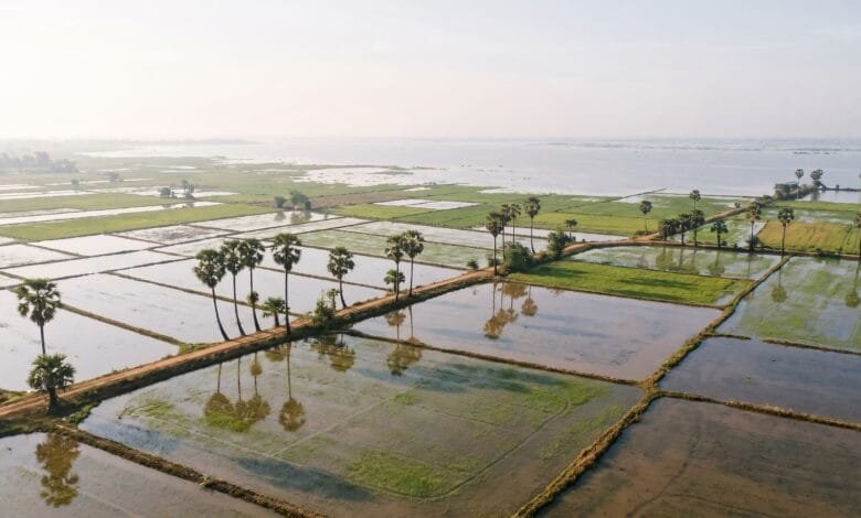
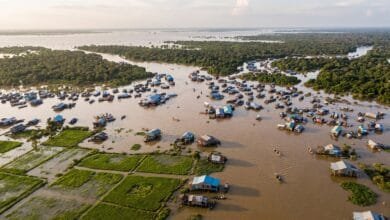
Fly into Phnom Penh or Siem Reap during the wet season and look out the window. You will not see mountains or forests or cities spreading to the horizon. You will see water — and then, threading through the water, an endless patchwork of green.
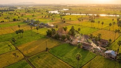
Rice fields. Thousands of them. Millions of them. They stretch across Cambodia’s central plain like a quilt sewn to fit the shape of the land itself.
This is not an accident of history or a simple matter of culture. Cambodia’s rice field landscape is a direct geographic consequence of where the country sits, how the land is shaped, and what the water does every year. Understanding that geography helps a traveler see Cambodia differently — not just as a country that grows rice, but as a country that was, in a real sense, made by the conditions that make rice the obvious crop.
A Country Shaped by Water and Flat Land
Cambodia covers about 181,035 square kilometers in mainland Southeast Asia. It borders Thailand to the north and west, Laos to the northeast, and Vietnam to the east and southeast. To the southwest, it meets the Gulf of Thailand along a coastline of roughly 435 kilometers.
But the number that matters most for understanding Cambodia’s rice landscape is simpler: about three-quarters of the country is plain. The central plain — low, flat, alluvial land surrounding the Tonle Sap Lake and the Mekong River — occupies the heart of the country and concentrates both population and agriculture.
That flatness is the first geographic requirement for a rice-dominated landscape. Rice, especially the wet lowland rice that defines Cambodian farming, needs level ground where water can sit evenly. Sloped land drains too quickly. Rocky land cannot hold water. Cambodia’s central plain is neither. It is the kind of land that collects water and keeps it — and then feeds it to rice.
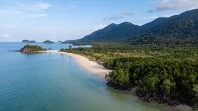
Mountains and plateaus ring this plain on three sides. The Cardamom and Elephant Mountains rise to the southwest, between the plain and the coast. The Dangrek Mountains line the northern border with Thailand. Hilly plateaus stretch along the eastern and northeastern borders. Together, these uplands cover roughly the remaining quarter of the country.
The result is a landscape with a clear geographic logic: a vast, flat, water-collecting basin in the center, surrounded by higher land that channels water and sediment inward.
The Central Plain: Cambodia’s Rice Heartland
Geographers and development agencies often divide Cambodia into three main topographic regions: the central plain, the surrounding mountains and plateaus, and the coastal zone. The central plain is by far the most important for rice.
This plain is not uniform. It includes several distinct sub-areas: the floodplain immediately around the Tonle Sap Lake, the broad valley of the Mekong River, and the lower-lying areas that extend toward the Vietnamese border. What these areas share is low elevation — mostly below 200 meters — and soils built from river sediment.
The plain’s agricultural importance is hard to overstate. The JICA regional development study notes that the plain’s rich sediment, deposited by the Mekong’s annual flooding, has made the agricultural lands “highly fertile”. Rain-fed rice production and truck farming dominate land use across this zone because the soil is good for cultivation.
This is where most Cambodians live. The population concentrates in the flood-prone area of the Mekong River basin, where rice farming has been the primary livelihood for centuries. The pattern is circular: flat land and water make rice possible, rice makes settlement possible, and settlement reinforces the rice landscape.
How the Mekong and Tonle Sap Built a Rice Landscape
If the central plain is the stage, the Mekong River and the Tonle Sap Lake are the engineers.
The Mekong is one of the world’s great rivers. It flows through China, Myanmar, Laos, Thailand, Cambodia, and Vietnam. In Cambodia, it feeds a remarkable hydrological system centered on the Tonle Sap, Southeast Asia’s largest freshwater lake.
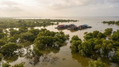
During the dry season, the Tonle Sap is relatively modest — about 0.24 million hectares. But when the monsoon rains arrive, the Mekong River swells. Its water level rises so much that it pushes back up the Tonle Sap River, reversing the river’s flow and filling the lake. The lake expands to an average of 1.08 million hectares during the monsoon, and in extreme years to as much as 1.75 million hectares.
When the floodwaters eventually recede, they leave behind two things that rice needs: water and nutrients. The receding waters deposit nutrient-rich sediments across the floodplain. They also leave standing water in low-lying areas, which sustains what researchers describe as “fertile rice fields”.
This annual cycle is called the flood pulse. It is the single most important geographic process shaping Cambodia’s rice landscape. Researchers estimate that approximately 85% of Cambodia’s paddy area is on the Tonle Sap floodplain, where rice depends on the natural flood pulse for residual soil moisture. The flood pulse also provides high water levels for irrigation and supports double-cropping systems during the wet season.
The geographic relationship is direct: the Mekong’s flood pulse creates the Tonle Sap’s expansion, the Tonle Sap’s expansion creates the floodplain, and the floodplain creates the conditions for rice on a scale that would be difficult to replicate with irrigation alone.
The Monsoon Climate That Makes Rice Possible
Cambodia’s climate is tropical monsoonal, with two distinct seasons. The wet season runs from May to October, driven by the southwest monsoon. The dry season runs from November to April, driven by the northeast monsoon.
For rice, the wet season is everything. Most rice-growing areas receive between 1,250 and 1,750 millimeters of rain annually, concentrated heavily in the May-to-October period. This rainfall, combined with the flood pulse, provides the water that lowland rice requires.
Cambodian farmers have adapted to this rhythm. The main rice crop — the wet-season crop — is planted with the arrival of the rains and harvested as the waters recede. This crop accounts for about 70% of annual production. A secondary dry-season crop, grown on about 30% of the annual area, depends on irrigation or residual moisture.
The climate does not guarantee a perfect harvest every year. Rainfall can be erratic. “Mini droughts” can occur even during the wet season, and farmers often prefer traditional photoperiod-sensitive rice varieties that are adapted to these conditions. In some years, flooding is too severe — in 2011, a mega-flood devastated more than 250,000 hectares of paddy. In 2025, localized losses occurred in parts of Battambang, Oddar Meanchey, and Siem Reap provinces due to below-average rainfall in July and August, while flooding affected lowland areas along the Mekong.
But over the long term, the monsoon pattern is remarkably consistent. It has been delivering water to Cambodia’s central plain for millennia, and rice has been the beneficiary.
Why the Soil Matters
Rice can grow in many soil types, but it grows best in soils that can hold water and retain nutrients. Cambodia’s central plain has both.
The soils of Cambodia’s rice-growing areas are diverse. Major soil groups include Prateah Lang (37% of total rice area), Bakan (18%), Tuol Samroung (16%), Krakor (11%), Prey Khmer (6%), Kbal Por (5%), and Kok Trap (3%). This variety reflects the different ways water has shaped the land over time.
In the broad alluvial plains along the Mekong and around the Tonle Sap, the dominant soils are Entisols and Inceptisols. Entisols are young soils with little horizon development — essentially fresh sediment laid down by rivers. The FAO’s soil classification notes that these soils “are generally more fertile than the soils of the inland plains”. They comprise about 0.5 million hectares of rice-growing land.
Inceptisols occupy intermediate positions in the landscape. They have a wider range of characteristics and considerable variation in their potential for growing rice.
Further from the rivers, on older terraces, Ultisols and Alfisols dominate. These soils are more weathered and leached. They have lower pH, potassium deficiency, and iron toxicity problems. Phosphorus deficiency is a major issue in both soil types. Rice is grown on these soils under rainfed lowland conditions across more than one million hectares.
The pattern is geographic: the closer land is to the river or lake, the younger and more fertile the soil. The flood pulse renews these soils annually. This is why the most intensive rice cultivation clusters around the Tonle Sap and along the Mekong — the geography of water and the geography of soil fertility overlap almost perfectly.
Where Rice Doesn’t Grow: Mountains, Plateaus, and Forests
Not all of Cambodia is rice field. The mountains and plateaus that ring the central plain tell the other side of the geographic story.
The Cardamom Mountains in the southwest are the largest remaining mountain forest in mainland Southeast Asia. Mount Aoral, at 1,813 meters, is Cambodia’s highest peak. These mountains receive heavy rainfall — more than 2,000 mm annually in some areas — but their steep slopes and dense forests make them unsuitable for wet rice cultivation.
The northeastern plateaus — in provinces like Ratanakiri and Mondulkiri — are also forested and hilly. Some rice is grown here, but it is upland rice, planted in unbounded fields on slopes rather than in flooded paddies. Upland rice accounts for a very small share of Cambodia’s total rice area.
The coastal zone along the Gulf of Thailand is a third geographic region. It includes mangrove forests, small strips of lowland, and coral reefs. Some rice is grown here, but the coastal zone’s agricultural character is different from the central plain. The dominant crops and land uses reflect the saltier, more maritime environment.
These non-rice landscapes matter because they show that Cambodia’s rice dominance is not inevitable everywhere. It is a geographic outcome. Where the land is flat and water collects, rice dominates. Where the land is steep and water runs off, forests and other crops take over.
What Travelers Notice in the Landscape
For a foreign traveler — especially someone from the United States or Europe — Cambodia’s rice landscape can be disorienting in its uniformity. From a bus between Phnom Penh and Battambang, or from a boat on the Tonle Sap, the view is often the same: flat land, water, and rice, repeated for hours.
A few things are worth noticing:
The geometry of the fields. Cambodian rice paddies are not random patches. They are bounded by low dikes called bunds, which hold water in place. From the air, this creates a grid-like pattern that contrasts with the irregular shapes of forests or cities.
The color shifts. Rice fields change color with the seasons. In the early wet season, they are flooded and reflective. As the rice grows, they turn bright green. By harvest, they are golden. Travelers who visit at different times of year see a different landscape.
The role of the Tonle Sap. If you visit Siem Reap and take a boat onto the Tonle Sap, you are seeing the heart of Cambodia’s rice geography. The lake’s seasonal expansion and contraction is the engine behind the paddies you see on the surrounding plain.
The absence of fences. Traditional rice landscapes in Cambodia are often open. The bunds between fields are low and easy to step over. This openness is a geographic and cultural feature — it reflects communal land use patterns that have evolved alongside the flood-pulse system.
Why This Geography Matters to Cambodia
Rice is not just a crop in Cambodia. It is the foundation of the rural economy, a staple food, and a cultural symbol. But the geographic conditions that make rice dominant also shape the country’s vulnerabilities and opportunities.
Rice accounts for about 25% of Cambodia’s agricultural GDP and roughly half of all agricultural crops’ value added. It is grown on about 83% of cultivated land by approximately 80% of farmers. When the monsoon is good, Cambodia produces more rice than it needs. In 2024, paddy production reached a record 14 million tonnes, and in 2025 it was forecast at approximately 14.6 million tonnes — about 17% above the five-year average. Cambodia exported 940,321 tonnes of milled rice in 2025, a 45% year-on-year increase.
But the same geography that makes rice possible also makes Cambodia vulnerable. The flood pulse is being altered by upstream dams, which dampen peak flows. Increasingly erratic rainfall is leading to more unexpected inundation events. Researchers describe a “shorter, smaller, and less predictable flood pulse” that threatens the flood-reliant rice systems anchoring Cambodia’s food security.
For travelers, this geographic understanding adds depth to the journey. The rice fields you see are not just scenery. They are the visible expression of a system that depends on the Mekong River, the Tonle Sap Lake, the monsoon, and the flat land of the central plain — a system that has worked for centuries but is now under pressure.
Frequently Asked Questions
Why is Cambodia mostly flat?
Most of Cambodia’s land area is the central plain, a low-lying basin formed by sediment deposited over thousands of years by the Mekong River and the Tonle Sap’s flood cycle. Mountains and plateaus ring this plain on three sides, but the center is flat and water-collecting.
What percentage of Cambodia is rice fields?
Rice is grown on approximately 83% of Cambodia’s cultivated land. The total cultivated area is about 24% of the country’s land surface, so rice fields cover roughly one-fifth of Cambodia’s total area.
Why does Cambodia grow so much rice?
The combination of flat land, monsoon rainfall, annual river flooding, and fertile alluvial soils creates ideal conditions for wet rice. Rice is also the traditional staple food and the most important agricultural export.
Is Cambodia’s rice landscape natural or human-made?
It is both. The flat land, water, and soil are natural geographic features. The paddy fields themselves — with their bunds, irrigation channels, and planted varieties — are human-made systems that have evolved over centuries to work with the natural flood pulse.
What happens to the rice fields during the dry season?
Many rice fields are fallow during the dry season. Some farmers grow a secondary dry-season crop using irrigation. Others grow other crops like mung beans or sesame, or leave the land to rest until the next monsoon.
Does the Tonle Sap affect rice farming?
Yes. The Tonle Sap’s annual flood pulse deposits nutrient-rich sediment across the surrounding plain and provides water for irrigation. Approximately 85% of Cambodia’s paddy area is on the Tonle Sap floodplain.
Is rice farming the same everywhere in Cambodia?
No. Rainfed lowland rice dominates the central plain. Upland rice is grown in the northeastern plateaus. Deepwater or floating rice is grown in the lowest parts of the floodplain. The geographic variation in water depth and timing produces different rice-growing systems.
Can travelers visit rice fields in Cambodia?
Yes. Rice fields are visible along most roads between major cities. The area around Battambang is particularly well known for its rice landscape. The Tonle Sap’s floating villages offer a different perspective on the same geographic system. Travelers should respect private land and local farming communities.
Conclusion
Cambodia’s landscape is dominated by rice fields because of a geographic system that fits together almost perfectly: flat land that collects water, a river that floods on schedule, a lake that expands and contracts like a breathing lung, a climate that delivers rain when rice needs it, and soils that are renewed by sediment every year.
This system is not unique in Southeast Asia, but it is particularly concentrated in Cambodia. The central plain’s combination of topography and hydrology makes rice the natural, almost inevitable, dominant crop. Where the land is flat and water arrives reliably, rice fields follow.
For a traveler, understanding this geography changes what you see. The green paddies from the bus window are not just scenery. They are a visible record of how water, land, and people have shaped each other in Cambodia over centuries. When you understand that, the landscape becomes something to read, not just to look at.